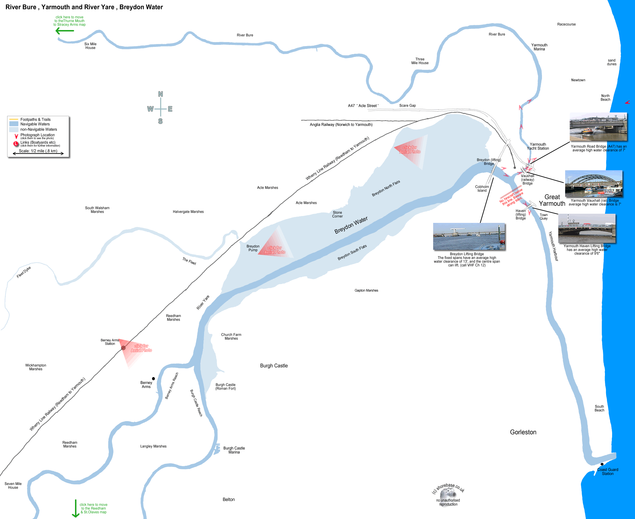
Yarmouth yacht Station, taken from the upstream side of the A47 Road Bridge The mouth of the River Bure and Breydon Bridge, taken from Vauxhall Rail Bridge (now a footbridge). move to next map move to next map The River Yare looking towards Breydon Bridge from Yarmouth Haven Bridge. The lifting road bridge spanning the northern end of Breydon water. The iron railway bridge over the River Bure, (now disused). My old Hardy Pilot heading up the River Bure from Yarmouth. The view astern shows the start of the town, just before the Yacht Station. Shoal Waters (owned by the author Charles Stock), heading upstream on the River Bure just above Yarmouth. Looking southwest down the River Bure towards Yarmouth yacht station. One of the many (well marked) obstructions in the river. Vauxhall Bridge at Great Yarmouth originally carried the railway to the eastern side of the River Bure. The terminus is now on the western side, and the dilapidated bridge has been reduced to a public footpath. A panorama of Breydon Lifting Bridge at Great Yarmouth. Tall boats pass under the centre span when raised, other boats can pass under the next nearest span each side. (scroll the page to see the whole picture) Haven Bridge at Great Yarmouth opens to pass a yacht through to Breydon Water. The A47 road bridge crossing the River Bure near the junction with the River Yare and Breydon Water. The southern end of Breydon Water, where the River Waveney and the River Yare join it. The Berney Arms is visible at the bottom right. (photo taken facing South East) Breydon Water at high tide facing north east towards Great Yarmouth. Breydon lifting road bridge is visible at the top centre. Great Yarmouth from Breydon Water facing east. Breydon Bridge is visible to the right of centre. The Bure snakes inland to the left, and the Yare turns right through the harbour to the sea. The new offshore wind farm at Scroby Sands, Great Yarmouth.

This page contains a scale map section of the Norfolk Broads.    (c) shorebase.co.uk
It is larger than your screen, so you will need to scroll the page to view it all.
Although hand-drawn, it is to the scale shown, and the positioning of the rivers and broads is accurate.
Wherever your mouse cursor changes to a pointer, 'popup text' will give more information.
The red angles are 'hotspots' for photos taken at that point, which you may then click to display them.
The other red markers are 'hotspots' to businesses & web links at that point, which you may then click to view.
If the photos or links don't appear when clicked, it may be caused by 'Advert Blocking' in your browser or firewall.