This page contains a scale map section of the Norfolk Broads.    (c) shorebase.co.uk
It is larger than your screen, so you will need to scroll the page to view it all.
Although hand-drawn, it is to the scale shown, and the positioning of the rivers and broads is accurate.
Wherever your mouse cursor changes to a pointer, 'popup text' will give more information.
The red angles are 'hotspots' for photos taken at that point, which you may then click to display them.
The other red markers are 'hotspots' to businesses & web links at that point, which you may then click to view.
If the photos or links don't appear when clicked, it may be caused by 'Advert Blocking' in your browser or firewall.
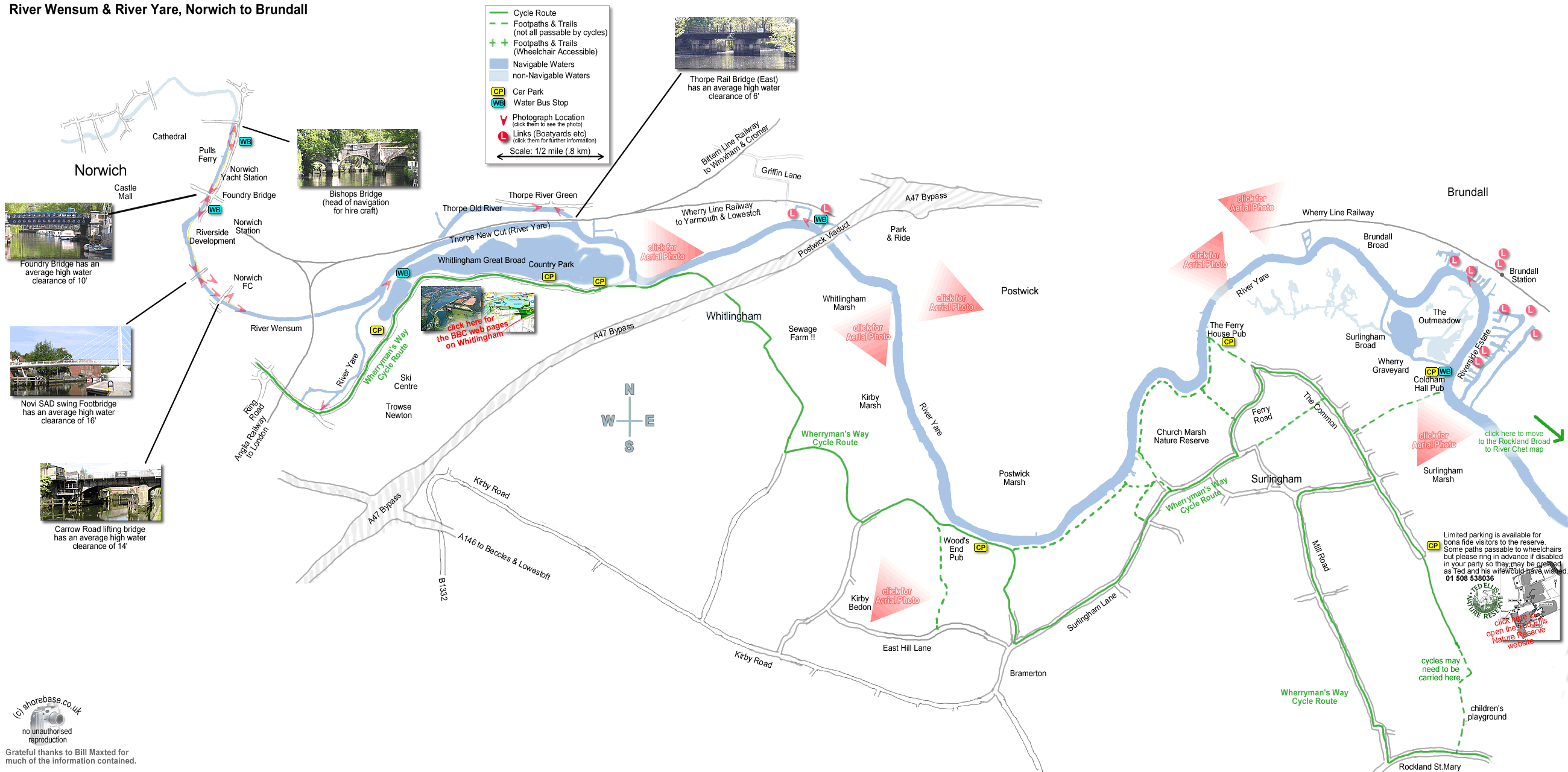
Boatshed Norfolk move to next map The upper River Yare, taken above the junction with the River Wensum. (photo by Bill Maxted). Bishop Bridge, Norwich. A hundred metres upstream of the Yacht Station, this is the head of navigation on the River Wensum for hire boats. The river Wensum immediately downstream of Bishops Bridge. The Norwich Yacht station runs along the left bank to Foundry Bridge, and Pulls Ferry is half way along the right bank. Norwich Yacht Station, River Wensum. Looking upstream from Foundry Bridge.) River Wensum, Norwich. Looking downstream from Foundry Bridge. (The large vessel on the left is the sea scout headquarters) Foundry Bridge over the River Wensum in Norwich, taken from the downstream side. Norwich Yacht Station can be seen on the right bank through the arch. The view upstream from the new NOVI SAD footbridge over the River Wensum in Norwich. The spire of Norwich Cathedral is visible, and the new Riverside development is on the right hand bank. The upstream view of the Carrow Road Bridge over the River Wensum in Norwich. The new NOVI SAD friendship (swing) bridge over the River Wensum in Norwich. Industrial buildings alongside the river Wensum in Norwich, upstream of Carrow Road bridge. Carrow Road Bridge over the River Wensum in Norwich. This photo shows the operators cabin and part of the lift mechanism. Carrow Road lifting bridge over the River Wensum in Norwich, taken from the downstream side. The Thorpe Old River (River Yare) at Thorpe, Norwich facing upstream. (This section is isolated from the main stream of the Yare by two very low fixed railway bridges.) Anglia Railways train heading east over one of the two Thorpe bridges. These are fixed and have an average hw clearance of only 6ft  . This makes this section of the Yare very quiet as the main river bypasses this ¾ mile section (via the Thorpe New Cut). The River Yare at Brundall looking East (downstream). The photo was taken from the Landing stage of the Yare Boatique store (Brundall Angling & Marine Centre). An aerial view of Postwick Viaduct, carrying the A47 over the River Yare, with the city of Norwich beyond. Postwick Viaduct, carrying the A47 over the River Yare on the edge of Norwich. (Looking downstream) Brundall Riverside Chandlery Brian Ward (electrical) Norfolk Yacht Agency AR Peachment The junction of the River yare and the River Wensum, at Whitlingham Country Park. (photo by Bill Maxted) The River Yare facing westwards past Thorpe St Andrew and Whitlingham Country Park. The River Yare bending around Postwick Marsh, facing North East. (Brundall is in the top right hand corner). The River Yare, entering Norwich from the east, under Postwick Viaduct. The sewage works on the left is what gives that strange aroma on the A47 on hot summer days... Church Marsh Nature Reserve on the River Yare. With Postwick Marsh on the right, the River Yare wends it  s way upstream to Norwich. Brundall from the South. The river curves upstream to Norwich on the left. Coldham Hall is at the bottom left. The River Yare, facing downstream, with Surlingham Broad on the right. Brundall is in the distance, top right. The Ferry House Pub is in the bottom right corner.