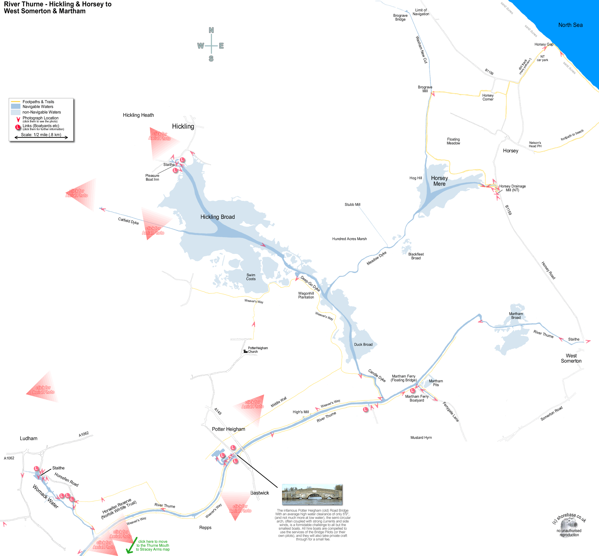
This page contains a scale map section of the Norfolk Broads.    (c) shorebase.co.uk
It is larger than your screen, so you will need to scroll the page to view it all.
Although hand-drawn, it is to the scale shown, and the positioning of the rivers and broads is accurate.
Wherever your mouse cursor changes to a pointer, 'popup text' will give more information.
The red angles are 'hotspots' for photos taken at that point, which you may then click to display them.
The other red markers are 'hotspots' to businesses & web links at that point, which you may then click to view.
If the photos or links don't appear when clicked, it may be caused by 'Advert Blocking' in your browser or firewall.
move to next map Looking north west along the Waxham New Cut opposite Brograve Mill, near Horsey Mere. Weather sculpted break waters on Horsey Beach. The picture was taken facing south east. The view through Horsey Gap, facing inland. The area is surrounded by a wide belt of scrub and sand dunes. (The National Trust car park can be seen in the middle distance.) Horsey Dyke, Horsey Mere. An early summer morning at Horsey Dyke, looking towards the Mere. Private Boat Dykes adjacent to the Pleasure Boat Inn at Hickling Broad A panorama of Hickling Broad taken from the gardens of the Pleasure Boat Inn <br> (scroll the image sideways to see the whole view) The Pleasure Boat Inn opposite the Staithe at Hickling Broad Crossing Hickling Broad in our old Hardy Pilot, looking west from Heigham Sound. Catfield Dyke, looking towards Hickling Broad (about half a mile away!). Candle Dyke, looking west towards Heigham Sound, Hickling Broad. A Westerly 22 rounding the corner from Candle Dyke into the River Thurne. Moored yacht in dyke off the River Thurne facing North West near Martham. Our Hampton Safari returning to the water after her refit at the Martham Boat Development Co. on the river Thurne. The public footpath along the Eastern bank of the River Thurne. The path runs behind the chalets lining the riverbank, with open farmland and grazing marshes behind them. (Photo looking south towards Potter Heigham.) Looking South East down the Dyke, away from the River Thurne. River Thurne looking North (upstream) with the Martham Ferry floating bridge in the foreground. Looking north west across the River Thurne at some of the riverside bungalows. (Above Potter Heigham Bridge). The River Thurne at West Somerton, looking southwards (downstream). This is the uppermost limit, with the sea less than a mile away. The view from the top of the NT Horsey Windpump looking south eastwards towards West Somerton. The Bloodhill wind farm can be seen on the skyline. a panorama of Horsey Mere taken from the top of the National Trust windpump<br>(scroll the image sideways to see the whole view) A still summer morning at Horsey Dyke, looking towards the National Trust Wind Pump. Horsey Dyke, looking towards Horsey Mere Horsey Mere Windpump, standing at the northern end of Horsey Dyke (National Trust). The road that led to the original Staithe at Ludham Village, looking north towards the village Womack Staithe, near Ludham Village A very frozen Womack Water from the corner of Ludham Staithe, looking towards the River Thurne. Horsefen Road, Ludham. Looking towards the village and away from the staithe a Wherry weathervane on the old houses at Ludham Staithe, Womack Water. The Bridle Path running along the western edge of Horsefen (a Norfolk Wildlife Trust Reserve), bordering Womack Water.(View taken facing North-east). Part of the Hunter fleet of traditional Broads Yachts, all spick and span for the new season. The yard is located at the end of Horsefen Road, Ludham. The River Thurne, looking north, upstream, about half a mile south of the entrance to Womack Water. The Norfolk Wildlife Trust nature reserve at Horsefen, Ludham. The photo was taken from the public bridleway that runs alongside, looking Eastward towards the River Thurne. The River Thurne about 1 mile south of Potter Heigham. The first few of the riverside bungalows are on the right. Herbert Woods Marina, Potter Heigham (frozen), with the River Thurne in the distance. Hampton Safari hire cruiser passing under the old Potter Heigham road bridge, heading northeast A tight squeeze for a traditional Broads yacht as she emerges from the downstream side of Potter Heigham Bridge. The Bridge Pilot office at Potter Heigham. They also run the Phoenix Fleet of electric powered dayboats. The narrow dyke leading to Womack Water from the River Thurne. Hunters Yard and The Norfolk Wherry Trust buildings can be seen in the distance. A distant view of Thurne, taken across the fields from Hall Road (Ludham), about 2 miles away. This shows how flat the farm land is around this area. (The photo was taken at 10x telephoto on the Olympus). A riverside bungalow on the River Thurne. Hickling Broad looking South-East with Whispering Reeds Boatyard and the Pleasure Boat Inn in the foreground. Hickling Broad, looking East with Horsey Mere and the North East Norfolk Coast beyond. The long straight Catfield Dyke can be seen running in from the foreground. Potter Heigham, looking southwards. Womack Water is just visible at the centre top, and Bure Mouth can be seen in the top left-hand corner. Womack Water looking North West. Ludham Village and Church are on the middle right, and Barton Broad can just be seen in the distance to the right. The Upper Thurne facing South East. Between Martham Ferry and Martham Broad. West Somerton Wind farm is just visible on the horizon, top right. The last 300 yds of the River Thurne before the head of navigation at West Somerton Staithe. (Facing North). The wherry Hathor being turned at Potter Heigham. (She was originally built for pleasure use for the wealthy Boardman Family of How Hill. A steam launch puffs silently down Womack Water on a crisp November afternoon. Whispering Reeds Hickling Broad Sailing Club Hunters Yard Norfolk Broads Direct Repps Staithe Boatyard Martham Boat Building & Dev Co. Ltd. Colin Buttifant Lathams of Potter Heigham Hickling broad from the South. Catfield dyke is partially visible along the bottom edge, with the Staithe and Hickling Sailing Club just to the right of the centre. The coast is just visible at the top of the photo. Looking across Potter Heigham towards Hickling Broad (facing North). Hickling Broad, taken from the North West corner. A private road, but public footpath, that runs along the northern edge towards the NWT reserve. Womack water from the East. This photo was taken after the Defra flood defences scheme, showing the new Soke Dyke to the left of the navigable channel, making it look like a dual carriageway ! The Steam Launch Falcon, and the Wherry Maud, during one of the Ludham Open Garden days. Taken from a private garden along Womack Water. A view from the footpath south of Hickling Broad towards Potter Heigham Church (visible on the right hand side). Martham Ferry Dyke, taken from the end, facing North West. A secluded landing stage along the public footpath bounding the southern edge of Hickling Broad & Heigham Sound. Thees two public slipways give access to Hickling Broad via the dyke behind the Pleasure Boat Inn. There is nearby parking, and a small fee is payable to Hickling Parish Council. The public toilets are visible in the background. Final Approach to Ludham Airfield from the West. The runway is the black tarmac strip visible in the bottom left corner of the windscreen.